
GOLDEN GATE NATIONAL RECREATION AREA
SF Map: C-E, 1-4
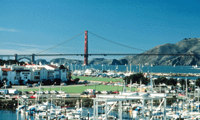
One of the largest urban parks in the world, the Golden Gate National Recreation Area (GGNRA) encompasses more than 72,000 acres with 28 miles of coastline and includes many of San Francisco and Marin County's most popular sights.
Take a scenic walk or bike ride along the three-mile Golden Gate Promenade which starts at Aquatic Park, passes Fort Mason and the Marina Green and ends at Fort Point near the base of the Golden Gate Bridge. Fort Mason is a renovated cluster of army barracks which house a variety of nonprofit organizations and small cultural museums.
Fort Point is a three-tiered brick structure built in 1853 to fortify the Bay Area during the Civil War. Although the fort contains 150 cannons, it was never used for active defense. Today it's a museum offering daily tours.


